Switching things up in the South Pacific
A map used to help teach English language skills on the island of Malekula in Vanuatu.
One criticism often leveled at the standard maps of the 20th century is that they represent a Eurocentric view of the world. The maps we see hanging in countless classrooms and depicted on globes aren’t necessarily to scale. Commercial maps often depict an outsize Europe and a shrunken Africa, and place Asia and the Pacific Ocean on the periphery. Intentionally or not, such depictions carry with them ingrained ideas and ideologies about the geography of the world and where countries and people belong in it.
The small multi-island nation of Vanuatu in the South Pacific has been home to Peace Corps Volunteers since 1990. When Nicole Bennett (Vanuatu 2015–17) decided to pursue the ubiquitous World Map Project as part of her Peace Corps service there, she started by addressing a glaring problem—Vanuatu didn’t appear on the map at all. So instead of using the longtime template developed by Peace Corps Volunteers and painted on walls in scores of countries, she decided to work with her students to create another map, one that put their own country smack in the middle. “I realized that the kids didn’t have access to a lot of visual information about Malekula (our island), Vanuatu, or the globe. Knowledge is power, and it is so important to understand where you are situated,” Bennett says. “Painting the island map was the most fun because as we started marking the names of different places, the kids would talk about their travels to see families in different villages. Having the local and contextual maps helps to bridge villages and build community.”
Today, Bennett is pursuing a doctorate in geography and has thought a lot about the way maps propagate systemic biases, often leaving certain people and places behind and presenting a distorted view of the world as it really is.
“When you switch things up, as we did, and place the Pacific in the center, you can see how vast the Pacific Ocean is. You appreciate more how much strength and wisdom it must have taken to cross the Pacific to populate the islands. This amazing feat is a part of this community’s heritage, and they should be proud of that. It also places Vanuatu near the center of the map, which is different because many commercially generated maps don’t include Vanuatu on them at all.”
In a world where information is increasingly presented in visual format, Bennett also saw value in using maps to teach other subjects, particularly languages local to Vanuatu, like Bislama.
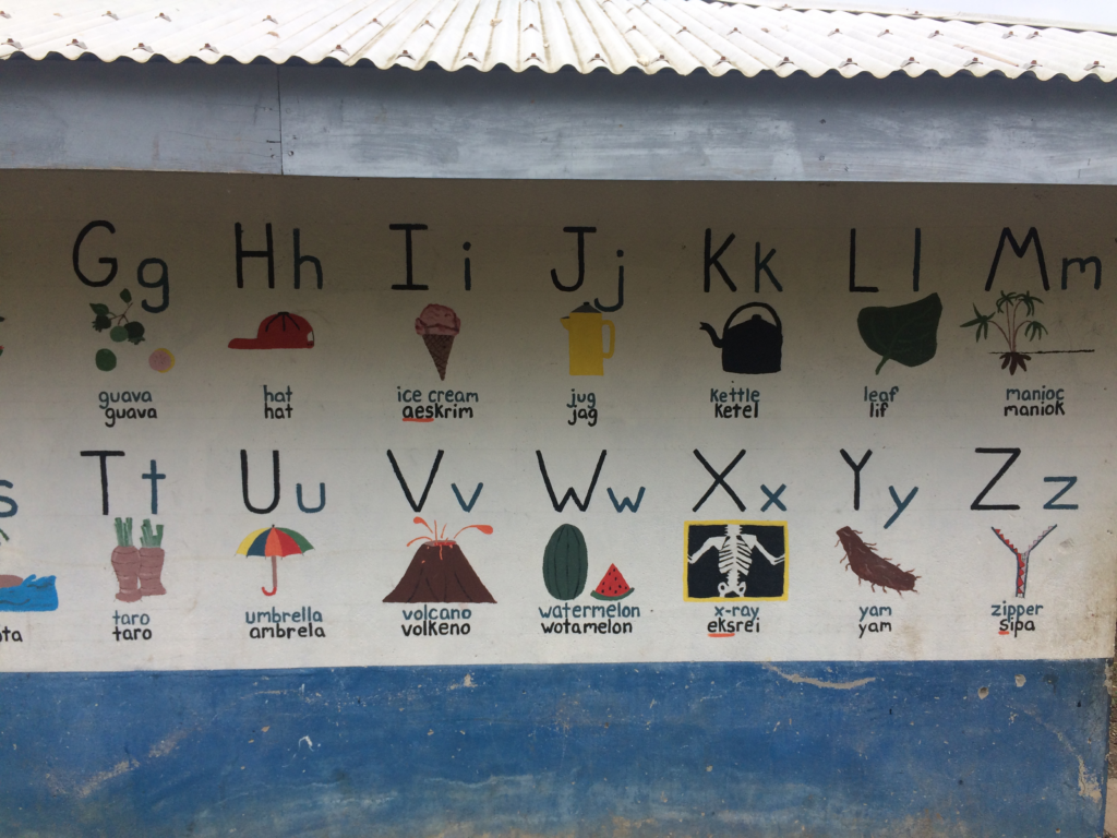
“As an English Volunteer, I ran small literacy groups of five to six children out of the second-grade classroom. We worked on reading and speaking English out loud. I noticed that the kids had trouble visualizing the letters and sounds. I think this stemmed from Bislama and the many other local languages coming from an oral tradition instead of a written one,” she says. “The idea behind the alphabet map was to help the students visualize the sounds they were speaking. If you look closely, you can see that we begin with the capital and lowercase letters that students traditionally see in school. We then painted a picture underneath, showcasing an object the kids would have seen in their surroundings. We then wrote the English word below the image, and then under that, we wrote the Bislama word. This helped the kids associate the sounds made with their mouths with a visual letter.”
The idea was to continue using maps to teach other subjects, but Bennett ran out of time—and space. “Other maps we considered were shapes, or numbers for math,” she says. “I would have loved to do a regional map showing other Pacific islands in geographic relation to Vanuatu, but we only had so much wall space.”